

Vision Based Navigation
AI-Powered Autonomous UAV Navigation in GNSS-Denied Zones
Project Overview
Unmanned Aerial Vehicles (UAVs) traditionally rely on GPS technology for navigation, however, when GPS signals are jammed or unavailable, the UAVs face significant limitations to perform intended functions. This necessitates the development of alternative technologies that enable UAVs to navigate and operate effectively in such environments. This project explores the potential of these technologies to create a robust navigation system that operates without reliance on GPS, focusing on the integration of image processing and AI-based solutions for real-time localization and navigation.
Image-based navigation overcomes the limitations of both GPS and inertial systems, providing accurate and reliable solutions in GPS-contested environments. This project seeks to build on these advancements to develop a reliable navigation system for UAVs when GNSS signals are compromised.
Vision Based Navigation Demonstration
Research & Development Approach
The necessary steps to achieve this objective are as follows:
Flight Test Results
After successfully validating the concept through initial simulations in Unity 3D, actual flights have been executed using a DJI drone:
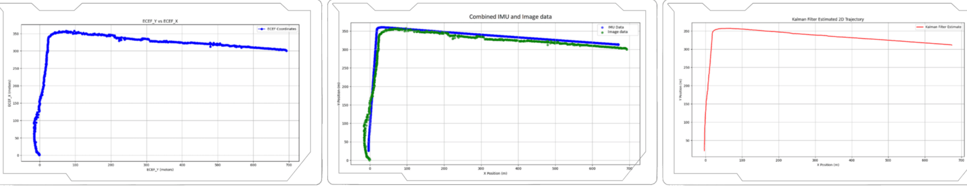
Figure 1: Drone flight path and Kalman Filter fusion results
Outcomes & Impact
Project Info
Client
PSDARC
Category
AI & Navigation